RÍOS / UCAYALI
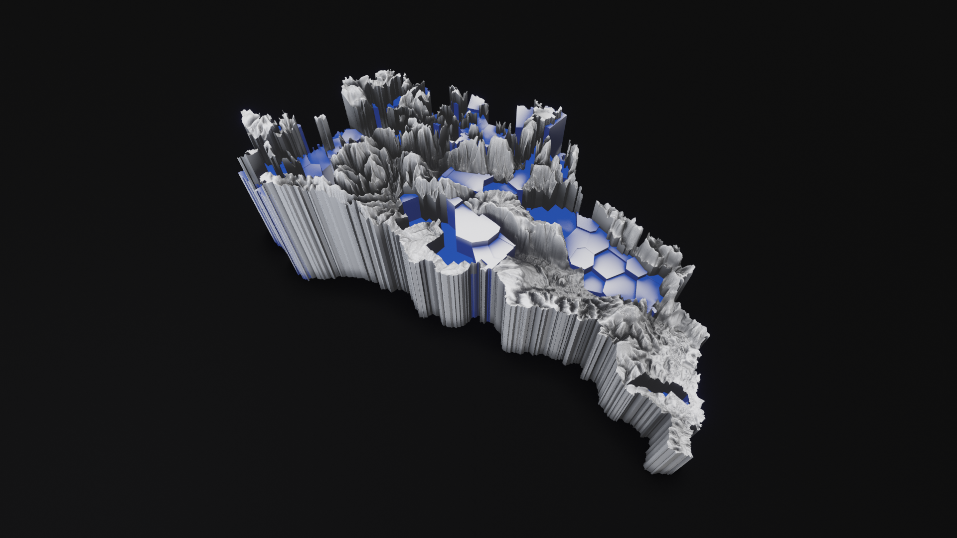
Ucayali + socio-environmental threatsTechnique: 3D printed porcelain
Dimensions: 158mm x 126 mm x 315mm (before baking, dimensions vary after the baking process)
Scale 1: 1,400,000
Limited edition: 3 copies + Artist proof
The digital elevation models used to generate the volumetric cartographic representations are based on topographic data combined with statistical data and geospatial socio-environmental information formulated by the RAISG (Amazon Geo-Referenced Socio-Environmental Information Network).
The geo-referenced information is associated with the linguistic analysis carried out by the online application Rivers // Amazonia geo-linguistic: https://rivers.ulara.org
The results of this analysis are applied to the geo-referenced marks where socio-environmental threats have been identified, by carrying out experimental interventions on the real topographic data of the Amazonian territory.
Based on the Ucayali Amazons sub-basin, stamped the 24th of June 2021 with data analysis performed by Rivers // Amazonia geo-linguistic.
The following hashtag associations were recorded to produce the sculpture:
Mineria, Amazonia, mining, ashaninka, deforestacion, awajún, povosindigenas, oro, acre, ojobiónico, kichwa, deforestation, Amazonía, plata, gold, business, cobre, quechua, copper, chequeosenlenguas, perú, Ecuador, mineriaresponsable, world, shipibokonibo, mineros, womeninmining, industrial, mujeresenmineria, mineriasubterranea, miner, maquinaria, maquinariapesada, Colombia, construccion, amahuaca, Ucayali, visibilidad, odeséate, silver, nature, ingenieria, miningengineering, petroleo, geology, energy, limoncocha, loreto, brasil, medioambiente, geologia, minerals, orellana, today, bandastransportadoras, igualdad, electricvehicles, movilidad, Rancagua, tech, selva, forests, sanmartin, savetheplanet, amazonas, mastanahua, biodiversidad, vialacosta, crudarealidad, conservacion, wallstreet, mexico, natureza, climateaction, sostenibilidad, news, cadenaverde, ecocidio, naturaleza, mina, Guaviare, nukak, eth, violencia, conflict, usa, peru, mineriachilena, septiembre, Patagonia, expominvirtual, indigenous, indigenas, Bolsonaro, climatechange, ethereum, bitcointrading, monero, bitcoinagile, surbitcoin, freebitcoins, deforestación, bitcoinart, bitcoinmalaysia, minera, carbon, industria, inversionistas, minas, subsecretariademinas, chile, litio, lithium, expominas, noviembre, Saturday, Monday, latinoamerica, perforacion, napo, rap, nahua, terramaz, arboles, trees, vida, politicaambiental, trading, cryptocurrency, petroenergia, amazoniacolombiana, usmca, inversionsegura, minero, minerals, queretaro, technology, inscripcionesabiertas, eventouexternado, congresonacional, argentina, battery, expominasvirtual, quito, coca, wampis, Mesoamerica, earth, planet, amazonforest, salvalaselva, animalplanet, savehabitat, coronavirus, mineriailegal, bosques, diainternacionaldelosbosquestropicales, costarica, nacion, crucitas ,infinitogold, cutris, ccss, feminicidio, lanacion, xmr, analytics, minería, angloamerican, mineriaargentina, metals, felizdoingo, sep, ocean, fracking, breaking, innovation, economics, rtscommissioning, diadeltrabajadorminero, indígenas, impactoambiental, transporte, vacuno, europeos, incendios, animals, menonitas, sosanimals, jairbolsonaro, madereros, ganaderia, incendiosforestales, taladearboles, talailegal, contaminación, forest, cambioclimatico, ecología, crisisclimatica, adobe, woods, apple, gopaperless, ecosistemas, pdf, ycmt, biodiversity, environment, incendioforestal, rainforest, amazon, calentamientoglobal, árboles, stopsulfatos, calidaddelaire, agosto, amazoniaenemergencia, amazoniacontracovid, beca, economia, foto, industry, mininglife, globalindustries, minamirador, mercurio, economiacircular, aridos, mineriasostenible, igualdadsalarial, codelco, goldfields, explotacionesacieloabierto, mlp, chuquisubte, antofagastaminerals, lomasbayas, feliz, sstavic, vivachile, cocelcoandina, latinamerica, mineracenizas, exploration, coppermining, perumining, seguridad, ecuadorminero, geostrat, buenjueves, energia, lojaresponsable, somosmineríaresponsable, nasdaq, dow, indices, guiaminera, deseptiembre, vxn, octubre, mineriaqueconstruyepa, ecomex, gyromaster, minasenmexico, geosintetios, cer, weinar, responsiblebusinessconduct, doingbusiness, mineríasostenible, huellahídrica, recursosvaliosos, magnetic, iman, imanes, engineering, finances, mundo, breakingnews, diamond, fire, suppression, aerosol, antioquía, cobalto, climate, coal, batteries, capacitación, mujeresenindustria, jungle, amazonie, culture, tradition, indigenouswomen, Arawak, papaiantônio, moyobamba, feriaam, tribunalconstitucional, bnamericas, aimara, Shipibo, petróleo, Venezuela, delitoambiental, noalarcominero, legend, rios, amazonfires, hidrovias, kukama, marañon, pueblosindigenas, Pucallpa, pueblosoriginarios, comandomatico, sabiduriaancestral, comunidadesnativas, ciencia, asesinatos, humedales, impresa, informacion, deltadelparana, cambioclomatico, ambiente, treeplantation, oxigeno, stopfire, worldsustenintable, respirar, diamundialdelmedioambiente, laguna, mueren, asivavendrell, losbosquesnosetocan, delitosambientales, tamshiyacu, justiciaparatamshiyacu, agricultura, selvatropical, conservation, clima, verde, treeplanting, fornature, treehugger, alllivesmatter, forestlovers, lifeonearth, infraestructuraverde, literaturaperu, literaturaamazonica, diamundialdelarbol, tropicalforestday, monocultivos, savetheamazon, record, animalrights, prayfortheamazon, prayforamazonia, America, amazonfire, armyhelptheplanet, sosindigenas, work, extinctionrebellion, fridaysforfuture, cambioclimático, climatecrisis, climateemergency, fauna, abejas, moscas, avispas, management, golondrinas, conflict, calor, aragón, stophunting, thema, telespires, hidroelectricas, amazoniabrasilera, amazoniaenllamas, persecución, militares, explosion, denuncia, ambientalistas, operativos, vlza, fuerzapública, archaeology, bronzeage, edaddelbronce, motordehidrogeno, menorcatalayotica, komatsu, treelife, williamsengineering, treelovers, vehículoeléctrico ,tree_love, dumper, treeworld, panelessolares, drones, periodismo, freedom, descolonial, lasustentabilidadesposible, Amazonian, madera, mineríaconrostrohumano, inversion, future, carbon, miners, economía, geo, dominio, historia, hierro, parquesnaturales, mujer, paisajeculturalcafetero, patrimoniodelahumanidad, sujetodederechos, canteras, graveras, industriaminera, industriaextractiva, seguridadysaludeneltrabajo, cleanenergy, fumigacionaerea, oceano, prehistoria, prehistory, edatdelbronze, desarrollo.
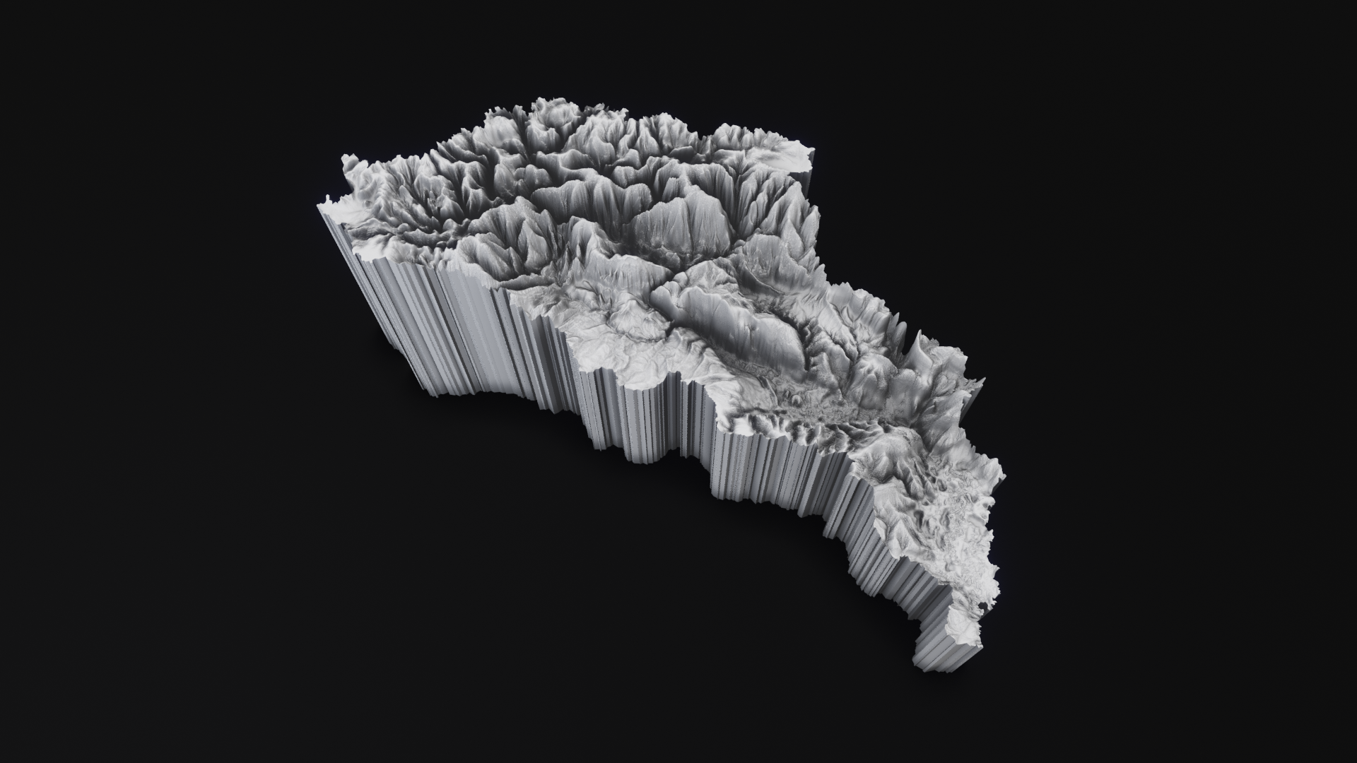

The Ucayali River is generally considered to be the main headwater tributary of the Amazon River. The Ucayali is approximately 2,700 km long, and its headwaters are about 6.400–6.800 km from the mouth of the Amazon River. Occupying approximately 353.000 km2, the Ucayali Basin is relatively smaller in area than the basins of other long tributaries of the Amazon River.
The Ucayali River generally flows southward between the high Andes to the west and low hills to the east. The river’s two main headwater tributaries are the Urubamba and the Tambo-Ene-Apurimac, whose headwaters rise above 5.000m. Three spectacular mountain ranges—the Cordillera Azul, the Cordillera Vilcabamba and the Cordillera Vilcanota—lie within the Ucayali Basin. The Cordillera Azul is in the Lower Basin, west of Pucallpa. The Cordillera Vilcabamba and the Cordillera Vilcanota lie within the headwaters region of the Ucayali near Cusco. The Ucayali River and its floodplain form a highly unstable network of levees, side channels, sandbars, mud bars, back swamps, lakes and islands.
Protected Areas
There are few functionally large protected areas in the Ucayali Basin. Except for Pacaya-Samiria National Reserve, which is mostly in the Marañón Basin, most of the protected areas in the Ucayali Basin are relatively small and confined largely to the cordilleras. The Cordillera Azul National Park protects one of the lower headwater areas of the Ucayali Basin. It is a mountainous area with sheer rock escarpments, lowland valleys, high-altitude lakes and marshlands. The Cordillera Azul lies west of Pucallpa and separates the Ucayali and Huallaga basins. Another important protected area in the Ucayali basin is the Otishi National Park, which is sparsely populated and designed to cover part of the area of the Tambo-Ene-Apurímac River, one of the two main tributaries of the Ucayali River.
Uses & Impacts
Human activities in the past 1000 years have heavily shaped the Ucayali Basin’s upper watershed landscape. The most famous headwater region of the Ucayali is the Sacred Valley, where such spectacular Inca ruins, as Ollantaytambo and Machu Picchu are located. The Incas farmed the Sacred Basin intensively and grazed animals on the floodplains and slopes, where they also built canals for irrigation and flood and erosion control.
Currently, deforestation of hillsides without terracing is recognized as a problem, and a few government reforestation projects exist. Pine or eucalyptus are typically planted and later also used for timber and firewood. Local pollution of streams near urban centres has been acknowledged as a serious problem.
There has been considerable recent highway and road expansion in the Ucayali Basin, including connections with the Interoceanic Highway from Brazil. The Cusco-Quillabamba railway, which trains began to use in the 1950s, has been replaced by a dirt road extending along the Urubamba Basin. Agricultural settlers from the high Andes have transformed the lower Vilcanota and upper Urubamba areas into a major agricultural frontier. These valleys have become important agricultural areas for tea, citrus, coca, coffee and bananas, among other crops.
The Lima-Pucallpa highway is the primary road to the middle Ucayali Basin, and although the highway has existed since the 1940s, Pucallpa did not grow rapidly until the mid-1980s. Both upland and floodplain deforestation is extensive near Pucallpa. Uplands have been deforested mostly for cattle ranching, whereas floodplain forests have been cleared to grow a wide variety of crops. The recent expansion of rice farms has also increased floodplain deforestation. Upland and floodplain forests are also being extensively logged for commercial timber.
Mining is widespread in the Ucayali Basin, especially in the higher regions, such as the Mantaro Basin, where Peru’s most famous and also infamous mining area because of dangerous pollution levels from heavy metals and other elements. The Mantaro Basin also contains the Mantaro Hydroelectric Complex, which is Peru’s main source of hydroelectric energy. Numerous dams have been proposed or considered on various tributaries of the Ucayali River. Challenges from indigenous groups and environmentalists and lack of financing have these on hold at the moment.
For complete information about socio-environmental threats, follow this link:
https://atlas2020.amazoniasocioambiental.org/en/posts/introduction
Sources:
http://amazonwaters.org/
https://www.amazoniasocioambiental.org


